Let’s Explore
Tanzania Great Rift Valley
Tanzania Great Rift Valley
The Great Rift Valley is one of the most fascinating natural landscapes in Africa. It is a huge geological system that stretches across East Africa, creating dramatic valleys, high escarpments, volcanic mountains, lakes, wetlands, forests, and open plains.
In Tanzania, the influence of the Great Rift Valley can be seen in many places, especially in the northern and western parts of the country. It has helped shape some of Tanzania’s most remarkable landscapes and natural attractions, including the Ngorongoro area, Lake Manyara, Lake Natron, Ol Doinyo Lengai, and the regions around Lake Tanganyika.
For visitors, the Great Rift Valley is more than a geological feature. It is a landscape where nature, wildlife, local communities, culture, and millions of years of Earth’s history come together.
What Is the Great Rift Valley?
The Great Rift Valley is a long geological depression created by movements within the Earth’s crust. Instead of being one single valley, it is a connected system of valleys and geological formations that extend across several countries.
The process began millions of years ago when enormous sections of the Earth’s crust started moving apart. As the crust stretched, it developed cracks and faults. Some sections of land gradually sank between these faults, forming valleys surrounded by steep mountains and escarpments.
At the same time, molten rock from deep beneath the Earth’s surface moved upward through the cracks. This created volcanic mountains, lava fields, hot springs, and other features that can still be seen today.
The process is still continuing. The Earth’s plates continue to move very slowly, meaning that the Great Rift Valley remains a changing and active geological landscape.
How Was the Great Rift Valley Formed?
To understand the Rift Valley, imagine the Earth’s crust as a large, hard outer shell made up of enormous pieces called tectonic plates. These plates are constantly moving, although their movement is usually too slow for us to notice.
In East Africa, the crust is gradually being pulled apart. As the plates move away from each other, the crust becomes stretched and thinner. Eventually, it cracks along large faults.
Some blocks of land between these faults sink while others remain higher. Over millions of years, repeated movements create deep valleys, high escarpments, mountains, and basins where water can collect.
Volcanic activity is another important part of the story. When the crust becomes thinner and develops cracks, magma can rise closer to the surface. This has produced many volcanoes and volcanic landscapes across East Africa.
This explains why areas around the Rift Valley contain both deep lakes and impressive volcanic mountains. They are different results of the same powerful geological process.
The Great Rift Valley in Tanzania
Tanzania occupies an important part of the East African Rift system. The rift has influenced the country’s landscape from the north to the west and has helped create environments that are now famous for wildlife and tourism.
Northern Tanzania provides some of the clearest examples. The landscape around Ngorongoro contains ancient volcanic features, while Lake Manyara lies within a dramatic rift valley setting. Further north, Lake Natron sits beneath the towering Ol Doinyo Lengai volcano.
These areas show how different geological processes can exist close together. Visitors can see steep escarpments, volcanic mountains, crater landscapes, alkaline lakes, forests, grasslands, and wildlife habitats within the same broader region.
The rift also extends through western Tanzania, where its geological influence can be seen around Lake Tanganyika and the surrounding mountains and valleys.
Ngorongoro and the Rift Valley
The Ngorongoro area is one of the best places to appreciate the relationship between volcanic activity and the Rift Valley.
Millions of years ago, volcanic activity created large mountains and volcanic landscapes in this part of northern Tanzania. Some volcanoes later collapsed or were heavily eroded, leaving behind impressive crater landscapes.
Today, the Ngorongoro Crater is one of the most famous natural features in Tanzania. Its enclosed grasslands, forests, wetlands, and water sources support a large variety of wildlife.
Although the crater itself is not simply a section of the Rift Valley, it forms part of the wider volcanic and geological landscape associated with the region.
For travellers, this provides a fascinating opportunity to see how geological history can influence modern wildlife habitats.
Lake Manyara and the Rift Valley
Lake Manyara is another excellent example of the connection between the Rift Valley and Tanzania’s natural environment.
The lake sits below the dramatic escarpment of the Rift Valley. The contrast between the steep escarpment and the relatively low-lying lake creates one of the most distinctive landscapes in northern Tanzania.
The area around Lake Manyara contains groundwater forests, woodland, grassland, wetlands, and lake habitats. These different environments support a variety of wildlife and bird species.
The lake itself can change considerably depending on rainfall and water levels. During wetter periods, it expands across the surrounding basin, while during dry periods, parts of the lake may become much shallower.
This changing environment is another reminder that the Rift Valley is a living landscape influenced by both geological and natural processes.
Lake Natron and Ol Doinyo Lengai
Lake Natron is one of the most unusual landscapes in Tanzania. It lies within the Rift Valley and is surrounded by volcanic terrain.
The lake is highly alkaline because water flowing into the basin carries minerals from the surrounding volcanic rocks. High evaporation then concentrates these minerals in the lake.
Despite these harsh conditions, Lake Natron supports important wildlife. It is particularly famous as a breeding area for lesser flamingos, which gather in large numbers when conditions are suitable.
Standing above the landscape is Ol Doinyo Lengai, an active volcano whose name means “Mountain of God” in the Maasai language.
The mountain is culturally important to the Maasai people and is also scientifically fascinating because of the unusual type of lava produced by its eruptions.
Together, Lake Natron and Ol Doinyo Lengai demonstrate the close relationship between geology, wildlife, and culture in the Rift Valley.
Tanzania's Great Lakes
The Rift Valley is closely connected with some of Africa’s most important lakes. These include Lake Tanganyika, Lake Malawi, and other smaller lakes found along different branches of the rift system.
Lake Tanganyika is particularly impressive. It is one of the deepest freshwater lakes on Earth and stretches along the western side of Tanzania. Its deep waters support a remarkable variety of fish and other aquatic life.
The lake is also important to the communities living along its shores. Fishing, transportation, agriculture, and trade all contribute to local livelihoods.
Lake Malawi, also known as Lake Nyasa, lies farther south within the wider East African Rift system. It is internationally recognized for its extraordinary diversity of freshwater fish.
These lakes demonstrate how tectonic activity can create enormous basins that eventually become important freshwater ecosystems.
The Eastern and Western Rift
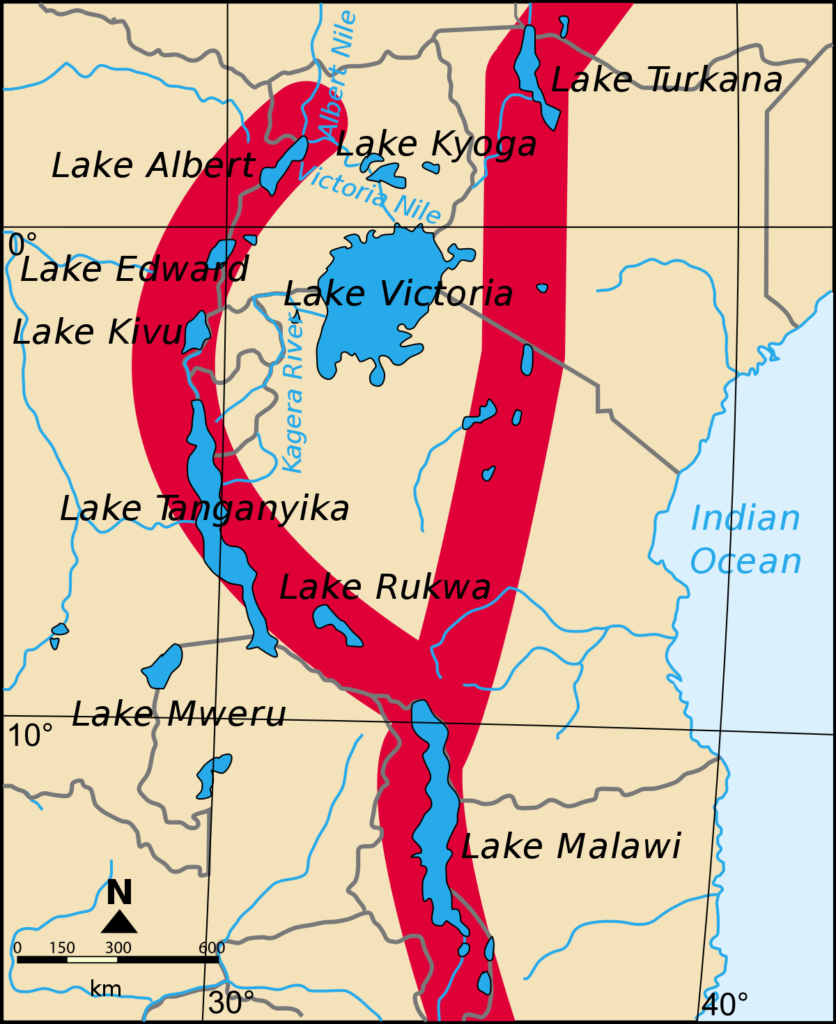
The East African Rift is generally described through two major branches: the Eastern Rift and the Western Rift.
The Eastern Rift passes through Ethiopia and Kenya before continuing into northern Tanzania. It is strongly associated with volcanic activity, alkaline lakes, mountains, and dry valleys.
The Western Rift, often called the Albertine Rift, follows a different route through the Great Lakes region. It includes areas around Lake Albert, Lake Kivu, Lake Tanganyika, and Lake Malawi.
Both branches have their own landscapes and ecosystems, but they share the same basic geological story: the Earth’s crust is being stretched and fractured.
The Albertine Rift
The Albertine Rift is one of Africa’s most important biodiversity regions. It contains mountains, forests, lakes, wetlands, and fertile valleys that provide habitats for an extraordinary range of species.
Some species found in this region occur nowhere else in the world. The area’s forests are particularly important for primates, birds, reptiles, amphibians, and other wildlife.
The Albertine Rift also supports many communities whose lives depend on agriculture, fishing, livestock, forests, and other natural resources.
Its importance therefore goes beyond wildlife conservation. Protecting these landscapes also helps protect water sources, forests, agricultural areas, and the livelihoods of millions of people.
The Rift Valley and Tanzania's Wildlife
The Great Rift Valley has played an important role in creating the habitats that make Tanzania one of Africa’s leading wildlife destinations.
Different geological environments produce different types of vegetation. Volcanic soils can support productive grasslands, while wetlands provide water and food for birds and other animals. Forested slopes create shelter for primates and other species, while open plains provide ideal grazing areas for large herbivores.
This variety helps explain why Tanzania can support such a wide range of wildlife within relatively short distances.
The Serengeti ecosystem, Ngorongoro area, Lake Manyara, Lake Natron, and other northern landscapes all demonstrate different relationships between geology, water, vegetation, and wildlife.
A Paradise for Birdlife
The lakes and wetlands of the Rift Valley are also extremely important for birds.
Shallow lakes and wetlands provide feeding and breeding areas for flamingos, pelicans, storks, herons, egrets, and many other waterbirds. Some lakes also serve as important stopping points for migratory birds travelling between different parts of Africa and beyond.
Lake Natron is particularly well known for its importance to lesser flamingos. The lake’s unusual chemical conditions create an environment where relatively few predators can reach their breeding areas, providing an important refuge for these birds.
For birdwatchers, the Rift Valley offers the opportunity to see both resident and migratory species while enjoying dramatic volcanic and lake landscapes.
People and Communities of the Rift Valley
The Great Rift Valley is not an empty wilderness. Millions of people live within and around its landscapes.
Communities have adapted their lives to the different environments created by the rift. Some depend mainly on farming, while others keep livestock, fish in lakes, or engage in trade and tourism.
In northern Tanzania, the Maasai are among the communities strongly connected with the landscapes around the Rift Valley. Their traditional way of life has developed around livestock, natural resources, and a deep cultural relationship with the land.
Other communities around the lakes and fertile valleys depend on fishing and agriculture for their livelihoods.
The Rift Valley therefore represents not only a natural heritage site but also a living cultural landscape.
The Rift Valley and Human History
The Great Rift Valley has an even deeper connection with human history.
East Africa is one of the world’s most important regions for the study of human evolution. Fossil discoveries in and around the Rift Valley have provided scientists with important evidence about early human ancestors and how humans developed over millions of years.
Tanzania’s Olduvai Gorge, located within the wider Ngorongoro landscape, is one of the most famous archaeological and palaeoanthropological sites in the world.
Discoveries from the area have helped researchers understand important stages in human evolution. This gives Tanzania’s Rift Valley significance not only for tourism and geology but also for understanding the history of humanity.
A Landscape That Is Still Changing
The Great Rift Valley may look permanent, but it is actually a landscape that continues to change.
The tectonic plates beneath East Africa are still moving. Earthquakes, volcanic activity, changes in lake levels, erosion, and sedimentation continue to reshape parts of the region.
Some volcanic areas remain active, while lakes can expand or shrink depending on rainfall and climate conditions.
These changes happen at very different speeds. Some geological changes take place over thousands or millions of years, while volcanic eruptions, earthquakes, and changes in water levels can occur much more quickly.
This continuing activity makes the Rift Valley one of the most interesting places on Earth for understanding how landscapes are formed.
Why Visit Tanzania's Great Rift Valley?
Exploring the Great Rift Valley adds another dimension to a Tanzania journey. A safari is not only about seeing lions, elephants, giraffes, or wildebeest. The landscapes where these animals live also have a story.
The steep walls of the Rift Valley, volcanic mountains, ancient craters, alkaline lakes, fertile plains, forests, and wetlands all tell part of that story.
Travelling through this region allows visitors to experience several sides of Tanzania at once: spectacular scenery, wildlife, birdlife, geological history, local cultures, and communities that have lived alongside these landscapes for generations.
From the volcanic slopes of Ol Doinyo Lengai to the shores of Lake Natron, the escarpments around Lake Manyara, the crater landscapes of Ngorongoro, and the deep waters of Lake Tanganyika, Tanzania’s Great Rift Valley offers an extraordinary journey through one of Earth’s most fascinating natural systems.
Experience the Great Rift Valley in Tanzania
The Great Rift Valley is a reminder that Tanzania’s landscapes were not created overnight. They are the result of powerful natural forces working over millions of years.
Today, those geological processes have created some of the country’s most beautiful and diverse destinations. Exploring the Rift Valley means discovering not only what Tanzania looks like today, but also understanding the geological story that shaped its mountains, lakes, wildlife habitats, and communities.
It is a journey through geology, nature, wildlife, culture, and human history, all connected by one of Africa’s most remarkable landscapes.
